

Large megalithic stone structures were created by man from Neolithic times for sepulchral as well as non-sepulchral purposes, including astronomy. One of the most spectacular and well known of these is Stonehenge in England, which has definite astronomical associations. Not many though, might be aware that India has its own version of Stonehenge. Located in Byse village in Karnataka these Megaliths structures dates back to 1000 BC and have been found to be aligned with certain Solar and Stellar movements including solstices and equinoxes.
Buddhist sculptures & Heads discovered in Pakistan

Archaeologists have discovered Buddhist sculptures and heads in Haripur district of Pakistan.
Buddhist sculptures and heads dating back to second to fifth century AD had been discovered by archaeologists during ongoing excavation at the site of an ancient Buddhist Stupa known as Bhamala Buddhist Complex.
The ruins of Telhara University older than Nalanda

Telhara is a village in the Nalanda district of Bihar, India. It was the site of a Buddhist monastery in ancient India. Located about 33 km from the ruins of the famous Nalanda University, Telhara could be ‘Tilas-akiya’ or ‘Tiladhak’, the place Chinese travellers Hiuen Tsang visited and wrote about during his travels through India in 7th century AD? So far, there were only vague references but recent excavations at the mound suggest that Telhara was indeed an ancient university, older than Nalanda and Vikramshila universities.
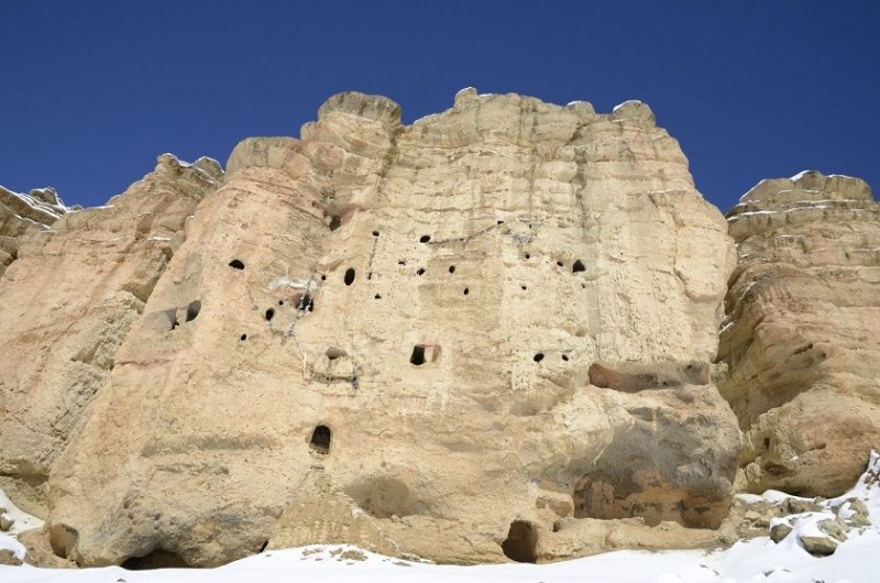
Mustang – Sky caves of Nepal

Mustang, the former Kingdom of Lo in northern Nepal is home to one of the world’s great archaeological mysteries. The region is known for it’s vast, mysterious, and nearly impossibly complex system of man-made caves. These mysterious caves nestled in rugged Himalayan terrain are around 10,000 in number. While some of them are easily accessible, others are too small to fit in a human.
Located at the height of 155 ft from the ground, these man-made caves are at least 2,000 years old but no one knows who built them or why. Or even how people climbed into them.
Some sit by themselves, a single open mouth on a vast corrugated face of weathered rock. Others are in groups, a grand chorus of holes, occasionally stacked eight or nine stories high, an entire vertical neighborhood. Some were dug into cliff sides, others tunneled from above. Some caves are even located on a single windswept rock and some were discovered to have been dug in such a way that it connects an entire neighborhood.
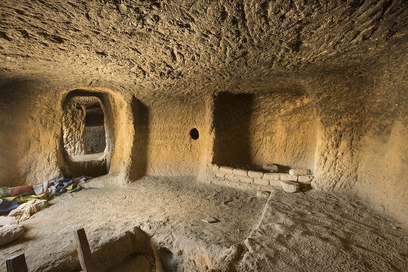
According to researcher, local used ramps or ladders to get to a level, and then the flats themselves. Inside the caves, vertical shafts have been found that connect the upper and lower levels together, and these likely had wooden ladders in them.
The residential caves also had kitchen areas, storage rooms with built-in containers, and rooms probably used primarily for sleeping.
While exploring these mysterious caves in Mustang, the researchers found priceless 14th-century wall paintings which included a 55 panel depiction of Buddha’s life, almost 3000 years old ancient human remains and centuries-old hidden library consisting of 8,000 calligraphed manuscripts—a collection, most of it 600 years old, that included everything from philosophical musings to a treatise on mediating disputes.
Scientists divide cave use in Upper Mustang into three periods. As early as 1000 BC, the caves were used as burial chambers. During the 10th Century, the region is thought to have been frequently battled over, and consequently, placing safety over convenience, families moved into the caves, turning them into living quarters. By the 1400s, the caves functioned as meditation chambers, military lookouts or storage units as people moved into villages.
In 2010, a team of mountaineers and archaeologists uncovered 27 human remains in Samdzong’s two biggest caves. The bones date from the third to the eighth centuries—before Buddhism came to Mustang—had cut marks on them. Scientists believe that this burial ritual may be related to the Buddhist practice of sky burial. To this day, when a citizen of Mustang dies, the body may be sliced into small pieces, bones included, to be swiftly snatched up by vultures.
Seven hundred years ago, Mustang was a bustling place: a center of Buddhist scholarship and art, and possibly the easiest connection between the salt deposits of Tibet and the cities of the Indian subcontinent. Salt was then one of the world’s most valuable commodities.
Later, in the 17th century, nearby kingdoms began dominating Mustang. Economy of Mustang started declining when cheaper salt became available from India. The great statues and brilliantly painted mandalas in Mustang’s temples started crumbling. And soon the region was all but forgotten, lost beyond the great mountains.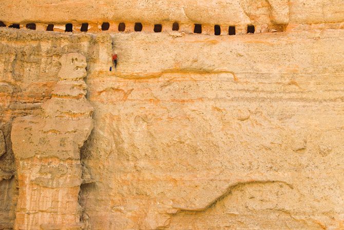
Even after the discovery and finding a little bit more about these caves many questions remains unanswered like “Who built them? Who lived there? What was the purpose of building them so high off the ground? How did they get inside the caves if it is so hard for the explorers to get to even with the help of modern equipments?”
Featured Image: Dailymail
Source: National Geographic
Drawings of Indus Valley discovered near Hampi

The Indus Valley Civilisation has puzzled archaeologists and researchers ever since it was first discovered in the early twentieth century. Who were these ancient people who lived along the Indus River between 3,300 and 1,300 B.C.? Could they have been wiped out by a flood or there may have been an epidemic or some terrible disease which killed the people? Or did they abandon the northwest part of the subcontinent because the river (Saraswati river) they depended upon dried up, or changed course, to migrate to other parts like South India?
The writing system of the Indus Valley Civilization is not deciphered and it still remains a mystery. All attempts to decipher it have failed. This is one of the reasons why the Indus Valley Civilization is one of the least known of the important early civilizations of antiquity.
“On the goddess Kotamma temple woollen market way there is a rocky roof shelter for shepherds and sheep to stay at night up to morning.”
The sentence emerged after a set of 19 drawing and pictographs discovered on a hilltop in Hampi (Karnataka, India) were deciphered using root morphemes of Gondi Tribe language.
Eleven of the Hampi pictographs resemble those of the Indus valley civilisation. This innocuous sounding statement could actually be a revolutionary find linking the Gond or Gondi tribe to the Indus Valley civilisation.
The Gondi people are a Dravidian people of central India, spread over the states of Madhya Pradesh, eastern Maharashtra (Vidarbha), Chhattisgarh, Uttar Pradesh, Telangana and Western Odisha. With over four million people, they are the largest tribe in Central India.
“Eleven of the Hampi pictographs resemble the Late Harappan writing of the Indus Valley Civilisation”, says Dr KM Metry, professor of tribal studies at the Kannada University. The professor claims that this shows that after the collapse of the civilisation situated in North-West India, the Harappans moved to other parts of the country, with some of them settling in Central India and a majority of them in the South.
Years of his research on Gondi culture, visits to tribal areas in Chhattisgarh and recent discovery of drawing led him to believe that undeciphered script of the Indus Valley Civilisation is a combination of Gondi symbols.
“The ability to decipher the script has proven elusive because no one has attempted to study the script using Gondi symbols and language. When you start looking at the script keeping in mind Gondi symbols, then everything becomes clear,” says Dr. Motiravan Kangali, a linguist and expert in Gondi language and culture from Nagpur.
Though the discovery is yet to be authenticated, Dr. Metry and his associates are very optimistic about their work. If the discovery stands the scrutiny of experts in the field, it would mean that the Gonds living in central and southern India could have migrated from the Indus Valley civilisation.
Featured Image and Source: The Hindu
Eternal Flames of Jwala Ji Temple

Jwala Ji is Hindu temple located in the lower Himalayan town of Jawalamukhi in Kangra district of Himachal Pradesh. Dedicated to Hindu goddess Jwala, temple is probably the most ancient temple in India. It is mentioned in the Mahabharata and other scriptures. Unlike any other temple, Jwala Ji temple doesn’t have a statue or an image, but a constantly burning blue flame that seems to come from the rocks. The flame can be seen at various places in the temple and it is burning continuously since first date of its known history.
Despite many scientific researches, the reason behind these natural flames couldn’t be found out. The scientists say there is a sleeping volcano under Jwala Ji temple and the natural gas coming out of that volcano is burning as flames, which Hindus revere as Goddess.
During 70s a foreign company was appointed by Government of India to explore possibilities of big reservoirs of natural gas there. They worked for some years but left saying they could not find any gas.
The Mughal Emperor Akbar once tried to extinguish the flames by covering them with an iron disk and even channelizing water to them. But the flames blasted all these efforts. Akbar then presented a golden parasol at the shrine. Even Aurangzeb, returned back to Delhi after knowing Maa Jwala Devi’s powers.
There is surely some other phenomena and science that is working behind Jwala Ji eternal flame but that can be indication of glory of our ancestors. Till now no scientists or geologists says nothing since they only tried their level best to find a clue but, failed.
History of Jwala Devi’s eternal flame
The legend of the Jwala Ji Temple relates to Sati -granddaughter of Lord Brahma and wife of Lord Shiva. It is here that Sati’s tongue fell which can now be seen in the form of the flame.
According to legends Sati immolated herself after her father insulted Lord Shiva. In his rage at loosing his wife, angry Shiva performed the fearsome and awe-inspiring Tandava dance with Sati’s charred body on his shoulders. During this dance, Sati’s body came apart and the pieces fell at different places on earth.
According to another version, Shiva placed Sati’s body on his shoulder and ran about the world, crazed with grief. The Gods called upon the God Vishnu to restore Shiva to normalcy and calm. Vishnu used his Sudarshana Chakra (a spinning, disk-like weapon) to dismember Sati’s lifeless body, following which Shiva regained his equanimity. Both versions state that Sati’s body was thus dismembered into 51 pieces which fell on earth at various places. These places came to known as Shakti Peeths. Sati’s tongue fell at the place where Jwala Ji temple is located and the goddess is manifest as tiny flame that burns flawless blue through fissures in the age-old rock.
History of Jwala Devi Temple
The temple is supposed to be first built by a king Raja Bhumi Chandra who, on the complain of a cowherd, tried to find out the a female who came out of the forest and drank the milk of his cow. Since, the king was aware of the legend of Sati, he continued his search for the place and finally succeeded. He constructed a temple there and employed priest to perform puja (prayer). Later, Pandavas came and carried out some renovation work in the temple.
The modern building of temple is with a gilt dome and pinnacles and possesses a beautiful folding door of silver plates, presented by Maharaja Kharak Singh. His father, Maharaja Ranjit Singh also presented the gilt roof in 1815 AD. The interior of the temple consists of a square pit about 3 feet deep with a pathway all around.
The term ‘Jwala‘ means “flame” in Sanskrit and ‘Ji‘ is an honorific used in the Indian subcontinent. Goddess Jwala is also referred to as Mata Jvala Ji and Mata Jwala Mukhi Ji.
14th Century Bronze Idols Discovered

Recently two bronze icons dating back to the Vijayanagar period have been found. The icons of Lord Vitthala and Lord Janardhana were found at the Janardhana temple in Belanje village near Hebri in Karkala taluk.
The icon of Lord Vitthala is 28 cm in height and stands on a lotus pedestal, while the icon of Lord Janardhana is 18 cm in height. Both icons were found by T. Murugeshi, associate professor in ancient history and archaeology.
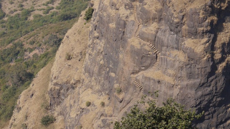
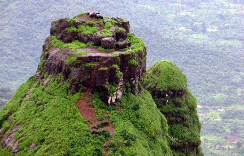
Prabalgad Fort – The Most Dangerous Fortress

Prabalgad Fort, also known as Kalavantin Durg, is located between Panvel and Matheran in the Indian state of Maharashtra. The structure is built at a height of 2300 feet on top of a plateau which is located close to Matheran. Previously, the fort was known as Muranjan until it was taken over and renamed by the Maratha forces under Shivaji’s rule.
This fort is built of granite stones cut from the same hills. The bonding materials used here is the commonly used lime stone. It has got thick and strong walls, which are still not weathered off. The fort contains a temple to Ganesh and some stone ruins. On the inner part, there are many small and medium complexes found here. It does have watch towers on its top.
The fort can be approached via a chillingly steep climb. The steps leading up to the fort were cut into the rock of the hill. There are no safety rails on the edge and no ropes on the wall to grab on to.
The origins of Prabalgad Fort are unknown but it is believed to have been built during the time of Buddha or in or around 500 BC for a queen named Kalavantin. It is a bit saddening for an explorer to know that this is the only information locals can give and so many marvels and mysteries of the fort have died without leaving a record behind.
Around 1458 Malik Ahmad, the prime minister of the kingdom of Ahmednagar, took over the fort during his conquest of Konkan. After the collapse of the Ahmadnagar Sultanate, the Mughals took control of Prabalgad along with Kalyan, Mahuli, Karnala and a number of other forts.
In the 1657 AD, the great Maratha King Shivaji Maharaj won this region with a great battle with the Mughals and took over this fort. At the time of the attack the fort was governed by Kesar Singh, a Mughal sardar, and was the only fort to put up a strong resistance. On seeing the signs of defeat the women in the fort performed Jauhar, a tradition of self immolation to ensure an honorable and respectful death. Kesar Singh died during the battle in October 1657, Shivaji in an act of kindness allowed Kesar Singh’s mother and her grandchild a safe passage out.
Soon after the decline of the Maratha Kingdom and the advent of British rule made many Indian to revolt against the British. As such one of the first men who protested against the British was Umaji Naik Khomane. He is belied to occupy this palace and was residing here mostly as a hideout place from 1826 AD to 1832 AD.

Prabalgad consists of a sister fort which is named Irshalgad Fort. It is situated in the vicinity of the main fort and is comparatively smaller in area. However there are numerous water reservoirs that were cut from rock.
From the top of the fort one can see Peb, Chanderi, Karnala and Irshalgad forts. The City of Mumbai is also visible and catching a bird’s eye view of the surrounding makes one wonder how people must have built such a marvelous structure with simple tools.

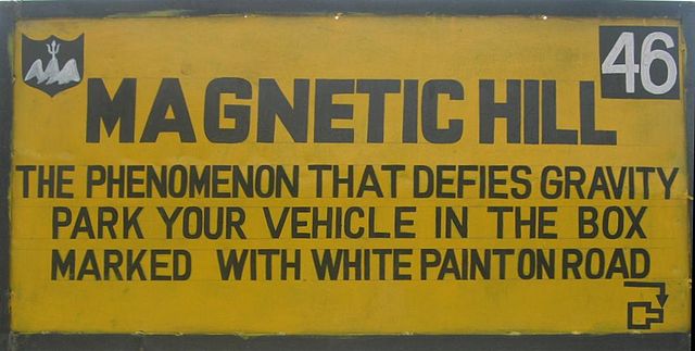
Magnetic hill of Ladakh

Can anyone ever imagine the movement of a vehicle up a steep mountain, with its ignition off? Sounds quite unbelievable! Well, this magnet magic can be experienced while you are traveling to Leh-Ladakh. Located about 30 km from Leh, at a height of 11,000 feet above sea level, the hill supposedly has magnetic properties which attracts metallic objects, making vehicles move up at a speed of about 20 km/h with their engines off.
Not only are the vehicles traveling on the road attracted by the magnetic powers of this hill, even the helicopters and aircraft feel the same magnetic impact. Locals and the Indo-Tibetan Border Police (ITBP) personnel claim that when the helicopters and aircrafts come with in the radius of this hill, they start to jerk. To avoid accidents, the fliers are advised to fly at specific speed and height. In fact, the Indian Air Force pilots always steer clear of the Magnetic Hill.
The local administration has also put up a bill board to help tourists recognize the Magnetic Hill. The board clearly states the phenomenon leaving you to try this experience for yourself.
What is the mystery of the Magnetic Hill in Ladakh?
There are many explanations to it. Some claim that the vehicles move because of the magnetic properties present in the hill. According to them, the magnetism here is so strong that it pulls the vehicles on its own. Others assign this spectacular phenomenon to supernatural powers.
However, a third explanation that is much closer to the truth is optical illusion. It is believed that the surrounding land at Magnetic Hill produces an optical illusion, which makes a downward slope appear upward. Thus, a vehicle left out of gear will appear to be rolling uphill.
Leh is one of the two districts that constitute Ladakh, the other being Kargil. It is a part of the Indian state of Jammu & Kashmir. The magnet Hill is located on the Leh-Kargil-Srinagar national highway, about 30 km from Leh. On its south side flows the Sindhu river (Indus), which originates in Tibet and goes to Pakistan.
A Sikh Gurudwara Pathar Sahib is located near the magnetic hill. The Gurdwara was built in 1517 to commemorate the visit to the Ladakh region of Guru Nanak Dev, the founder Guru of the Sikh faith.
Due to both the Gurudwara and the gravity hill, the area has become a popular sightseeing destination. The magnetic hill has become a popular stop for domestic tourists on car journeys.
New discovery may rewrite the history of Kolkata’s origin

Job Charnock is credited with having founded Calcutta, now Kolkata, in 1690. It was the capital of the British Indian empire until 1911 when the capital was relocated to Delhi. The word Kolkata derives from the Bengali term Kôlikata, the name of one of three villages that predated the arrival of the British, in the area where the city eventually was to be established; the other two villages were Sutanuti and Govindapur. But artifacts unearthed during a recent excavation could rewrite the history of the origins of this city.
Recent excavations, at the famous Dum Dum mound, which houses the Clive House — the oldest building in the city — have yielded remains of an urban settlement dating back to 2nd Century BC, which proved that urban settlements existed in Kolkata long before a colonial town came up in the triad of villages of Kalikata, Sutanuti and Gobindapur. The site remained in occupation almost till modern time, with a break during the 12th to 14th Century AD.
Artefacts from the excavation are various and include exquisite terracotta plaques and figures from the 2nd and 1st Century BC to 8th-9th Century AD. This excavation has proved that Kolkata was inhabited by civilised people who used materials normally found in an urban settlement. The discovery of various things bearing close resemblance at many artefacts that hints that the settlement was an extension of Chandraketugarh.
Chandraketugarh is an archaeological site located about 35 km north-east of Kolkata, where archaeologists discovered many artefacts dated from 400 BC to 100 BC. According to some historians, the Chandraketugarh site and surrounding area could be the place known to ancient Greek and Roman writers as ‘Gangaridai‘.
“The excavation revealed that Kolkata did not spring up suddenly. Traces of urban settlement found during the excavation bore a close resemblance with those found in an urban settlement at Chandraketugarh,” said ASI (Archaeology Survey of India) regional director P K Mishra.
There could have been more revelations if the ASI could complete the excavation. Archaeologists believe that the revelations will not only give a complete understanding of the origins of Kolkata, but they may as well unearth a whole city. But much progress could not be made as the site is surrounded by a densely populated urban centre and further excavation could risk damaging nearby buildings.
“An extensive excavation is required to understand the real history of the city. But whatever we have found is enough to rewrite the history of the city,” claimed Mishra.
Though evacuation of this site started as late as 2001, ASI officials came to understand its importance by chance, when a telecom company digging for laying cables dug up a plaque with inscriptions.
Featured Image: by Sushanta Patronobish
Source:
Chandraketugarh: A history of ancient and medieval India
Dum Dum mound may rewrite Kolkata history: Times of india
