Mahabalipuramis an ancient historic town in Kancheepuram district in the Indian state of Tamil Nadu. During the time of Periplus (1st century CE) and Ptolemy (140 CE) Mahabalipuram was a bustling seaport, used by Ancient Indian traders who went to countries of South East Asia.
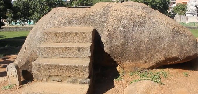
It has a group of sanctuaries, which was carved out of rock in the 7th and 8th centuries. Here in Mahabalipuram, we can find some evidence of ancient drilling technology. An eight feet wide, Giant hole is drilled out of granite rock. As we know Granite is one of the hardest rocks in the world and today we use diamond tipped tools and laser to make drills in it. How could ancient Indian drill a humongous hole like this 1300 years ago and why?
Called by locals as Seetha’s Bathtub, this Giant hole is 8 feet wide and 5 feet deep.The circumference is a perfect circle. Walls looks so smooth and looks like it is made with a modern machine.According to conventional history, People did not use any complex tools. But how can a perfect circle that is 8 feet wide be carved on a rock.Nobody knows the reason behind this giant hole drilled out of this rock.
Academics think that this was carved with chisels and hammers. If it was true, at one point, this would have taken years to make it look perfect. Why would they need to create a perfect cylinder out of a rock and what is the reason behind making it a perfect circle? If you wanted a well for water, you can dig one with much less manual labor. If you wanted to create a water tank, you can just use pots or metal vessels. Even water wells or tanks don’t need this much of effort. Was it used to fit something that was a perfect cylinder?
Another interesting Site at Mahabalipurum is Krishna’s Butter ball, a20 feet high and 5 meter wide rock estimated to weigh over 250 tons miraculously stands on an extremely small, slippery area of a hill.
A 5,000 years old stepwell has been discovered in one of the largest Harappan cities, Dholavira, in Kutch. Dating back to bronze age, the site represents the largest, grandest, and the best furnished ancient water reservoir discovered so far in the country. It’s rectangular and 73.4m long, 29.3m wide, and 10m deep and almost three times bigger than the Great Bath of Mohenjo-Daro, which is 12m by 7m by 2.4m. Archaelogists are hopefull that the reservoir might be listed with the UNESCO. Another site, the Rani ki Vav in Patan, is listed with the UNESCO already.
Experts will now start researching for the technology used in this Harappan stepwell as they say that there is a highly advanced hydraulic engineering that has been used here. The team will be using remote sensing technology, 3D laser scanner and ground penetrating radar system. How did water flow into the well? What was the idea behind water conservation? These are some of the questions that will be probed.
The stepwell that was found during the excavation. – Image Source
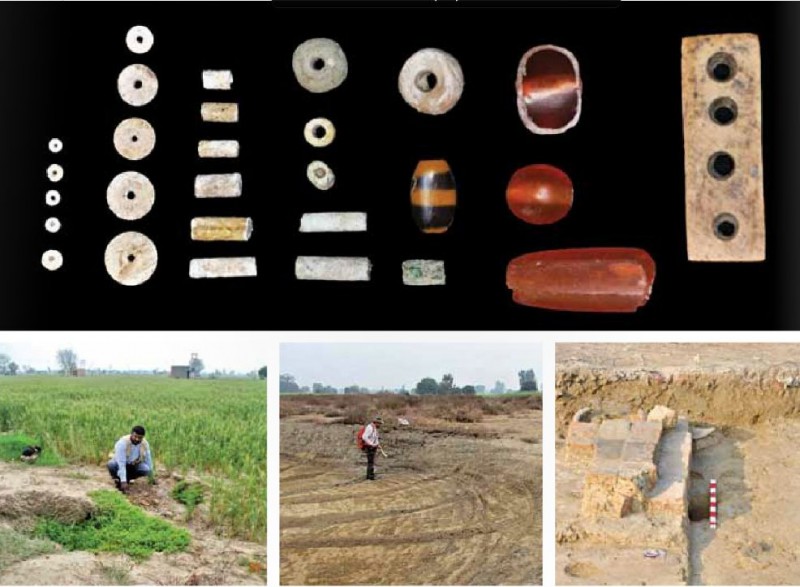
Various tanks, stoneware, finely furnished brick blocks, sanitation chambers and semi-precious stones such as carnelian, which were in great demand during the Harappan era, are expected to be investigated. Gujarat was the centre of bead and craft manufacturing, and agate carnelian beads were very popular.
A study of the internal structures of various forms of pottery will help them to identify the diet of various people here. The pottery typology will show what communities lived here, and what kind of precious copper and bronze artefacts were used.
V N Prabhakar, visiting faculty at IIT and superintending archaeologist, ASI said, “We will conduct spot analysis in December as various surveys have indicated other reservoirs and stepwells may be buried in Dholavira.”
To add further, he said, “We also suspect a huge lake and an ancient shoreline are buried in the archaeological site that’s one of the five largest Harappan sites and the most prominent archaeological site in India belonging to the Indus Valley civilization.”
Rakhigarhi is a village in Hisar District in the state of Haryana in India, around 150 kilometers from Delhi. Spread over 350 hectares, this nondescript village is biggest Indus valley Civilisation site in the world, a city that was much larger and more ancient than Harappa and Mohenjo-Daro sites. It is situated on the dry bed of the river Sarasvati, which once flowed here and is believed to have dried up by 2000 BC.
It is the only place which has the remains of early, mature and late phase of Indus valley Civilisation at the same location. It is one of the few Harappan sites which has an unbroken history of settlement—Early Harappan farming communities from 6000 to 4500 BC, followed by the Early Mature Harappan urbanisation phase from 4500 to 3000 BC, and then the highly urbanised Mature Harappan era from 3000 BC to the mysterious collapse of the civilisation around 1800 BC.
In January 2014, the discovery of two new mounds at the ancient Harappan site of Rakhigarhi makes it the largest known site of the Indus Valley civilisation. Until now, experts believed that Mohenjo-Daro in Pakistan was the largest among the 2,000 Harappan sites known to exist in India, Pakistan and Afghanistan. With the discovery of two more mounds, adding to the seven mounds already discovered, the total area of the archaeological site of Rakhigarhi now measures 350 hectares. The eighth and ninth mounds, spread over 25 hectares each, are situated to the east and west of the main site. Archaeologists also found numerous artefacts, some around 5,000 years old.
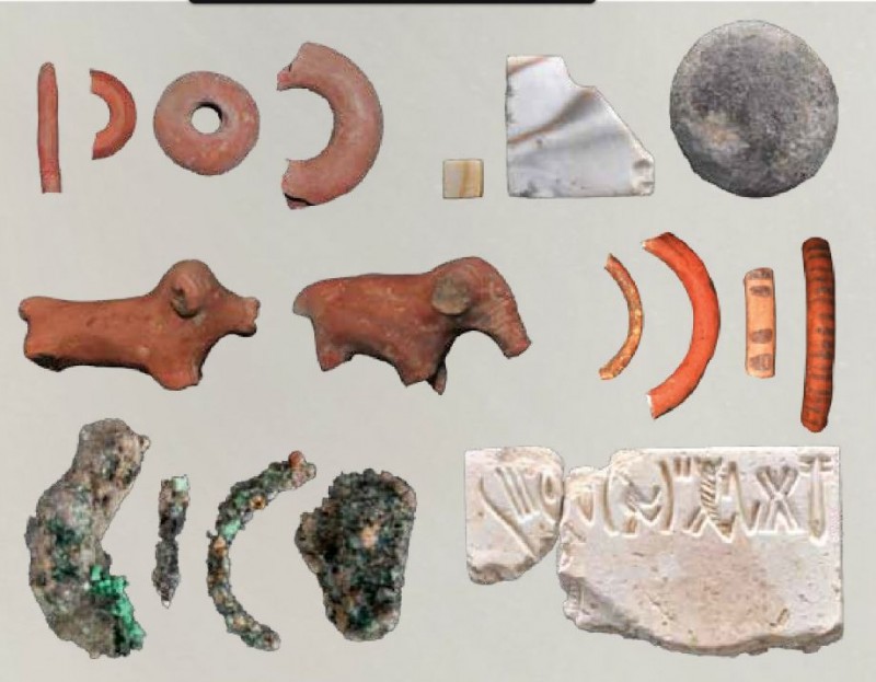
Terracotta toys, Broken bangle piece, copper objects and Harappan seal Dicovered at rakhigarhi. -Image by India Perspectives
Terracotta statues, bronze artefacts, copper fish hooks, terracotta seals a bronze vessel decorated with gold and silver were found here.
Recent excavations at the newly discovered and pre-existing mounds have also revealed a cornucopia of ancient artefacts including terracotta bangles; pottery pieces; a seal and a pot shard, both inscribed with the Harappan script; pot shards painted with geometric designs; and terracotta animal figurines, all belonging to the Mature Harappan phase of the civilisation. In addition, five trenches around the mounds have revealed residential rooms, a bathroom with a soak jar, drainages, a hearth, and a platform, all built with mud bricks.
A burial site, with 11 skeletons with their heads in the north direction, was dug out too. Utensils for everydy use were kept near their heads. Three female skeletons had shell bangles and a goldarmlet was found near one. Semi-precious stones were found too, showing they were part of a necklace.
One of the mounds found here also shed light on the Harappan’s occupational inclinations as it showed large scale burning, indicative of metal smelting and the use of furnace technology. Archeologists also found copper slags here, which mean that this part of Rakhigarhi was an industrial area. This finding is significant because though it was known that Harappans were industrially advanced, but there was no earlier evidence about the kind of technology they used.
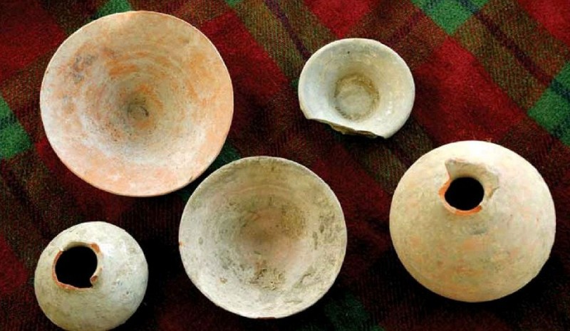
Pottery Items Dicovered at Rakhigarhi
“Rakhigarhi was occupied during early Harappan times as we have found eveidence of paved roads, drainage system, large rainwater collection, storage system, terracotta bricks, statue production and skilled working of bronze as well as precious metals. Jewellery, including bangles made from terracotta, conch shells, gold and semi-precious stones, has also been found. In fact, the site lies at the centre of Ghaggar Basin, the Harappan civilisation’s (2600-1900 BC) most densely populated region,” share Prof. vasant Shinde, senior archaelogist heading the excavations at Rakhigarhi.
It was in 1963 that Rakhigarhi first appeared on the archaeologists’ map when it was identified to have the remains of Indus Valley Civilisation. It was in 1997 that the Archaeological Survey of India (ASI) took the mounds under its protection and followed it up with exacations between 1998 and 2001 to reveal a city larger than Mohenjo-daro and Harappa. The rest of the ancient Harappan site of Rakhigarhi still lies buried under the present-day village. New houses are coming up at Rakhigarhi, which is destroying a big part of the Harappan site. One-third of the site is under cultivation.
Archaelogists believe that the beginning of the Harappan Civilisation took place in the Ghaggar Basin in Haryana, India and it gradually grew from here and slowly moved to the Indus valley. It was earlier thought that the origin of the early Harappan phase took place in Sindh, in present-day Pakistan, because many sites had not been discovered then. In the last ten years, Archeologists have discovered many sites in India, which are producing early dates and where the early Harappan phase could go back to 5000 BCE.
Ornaments made by steatite fience ivory bone and carnelian (below) At the excavation site and an excavated bathroom
The Indus Valley Civilisation is one of the three oldest urban civilisations, along with Egypt and Mesopotamia. Ancient India during the Harappan era had one of the largest populations in the ancient world, far greater than the Middle East or Europe.
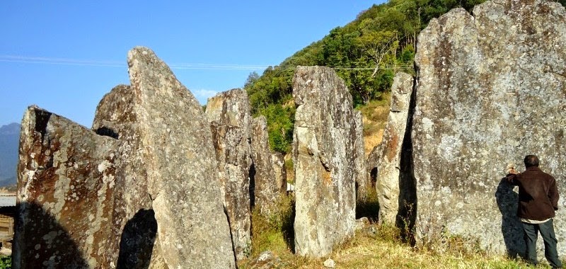
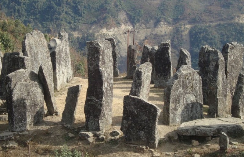
Located at a distance of 39 kilometers from the Maram Village in Manipur, Willong Khullen is characterized by its numerous stone erections which are similar to the Stonehenge. The tallest of the stones are as high as 7 meters and are about a meter in thickness. The place is located on the slopes of the valley and offers a serene picnic and resting spot for the travelers. It is said that the stones are uncountable as there is a spirit that would confuse you midway while counting.
According to local villager, these giant stone structures were ercted by their forefathers and this megalithic structures has a close connection with the mythology of the area. Each Stones has a unique story. They also believe that all the stones have their own name and they ‘really talk’ to each other at night. In male’s voice, each stone called one another with their names such as ‘Kala’, ‘Kanga’, ‘Hila’, etc.
Villagers explained that only a man of exceptional strength and power can think of erecting a stone at the site. He would have to go and find a suitable stone from a far off place and the villagers would assist him in bringing the stone to the village. Before bringing the stone to the village, the man have to fast for one whole night and perform a ritual by offering wine before the stone. Only after getting a favourable nod from the stone, he would be allowed to lift it from the original place. If the man found any difficult in lifting the stone then the villagers would sing a special folk song to bring it to Katak Tukhum area.
Megalithic structures at Willong village’s Katak Tukhum area in Mao-Maram
According to villagers, none could count the exact number of stones that have been erected at Katak Tukhum area. There is also a folk tale about a Japanese, who challenged to count the number of stones but had to retreat after a white wild boar chased him away from the place.
Even today, there is still a giant stone at the outskirt of the village which the villagers regarded it as sent by God to mark the demarcation of Willong village.
But with the advent of Christianity such tradition and culture of the Marams seem to be moving away. Fortunately there is still a microscopic minority among the Marams who have been bonding with their ancestral practices and beliefs. Because of this group of people we are indeed grateful in capturing a glimpse of the bygone remnants.
As only a few elders who know about the history of these stones are surviving today, villagers feared that all the folk songs, riddles, tales that are connected with these giant stones might be forgotten soon, never to be heard by the new generations to come. Most youngsters are in no mood to listen to all these stories to understand the importance of this historical legacy.
Expressing desire for declaring the area as a historical site, the villagers have also urged the state government and its department concerned to construct a building where all these stones, their associated folklores could be preserved. In fact, with an eye on keeping alive the historical legacy of Katak Tukhum, the process of collecting some folk tales and songs have already been started by the villagers themselves. However, the state government never bothers to preserve the age-old stones for future generations.
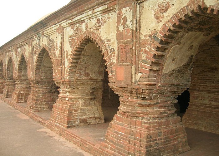
RasMancha is a pyramid like building located at Bishnupur, West Bengal, India.The name Rasmancha implies ‘a stage for dances’. The massive building was built in between the years of 1557 – 1600 A.D. by Malla King, Vir Hambir to celebrate the Vaishnava Ras festival.
During the Malla Regime, all the portraits from the neighbouring shrines were brought during the Ras Festival and exhibited in the open doorways for common public. The monument was also used to stage dances every evening to celebrate scenes from the Krishna Leela. However, it is no longer a temple today; it is an ancient monument now. The festival was last celebrated in 1932 after which the temple was declared a protected monument by the Archaeological Survey of India. Nowadays the annual festival has been shifted to the nearby grounds near the temple of Goddess Durga.
The temple is absolutely unique in style and architecture, not only in Bengal, but in India. It is the oldest brick temple in the town. The red brick structure of the building is in the form of a pyramid summit which is built upon a roomy platform. The foundation of the structure is 1.5 meters high with each side measuring 24.5 meters and rising to a height of 11 meters. It consists of a single chamber with an elongated tower which is surrounded by hut-shaped turrets. The masterpiece has 108 doorways and houses some large ancient cannons which date back to the Malla dynasty. The temple has three consecutive circumblatory galleries. The archways of these galleries are highlighted with terracotta lotus motifs, enclosing the sanctum of the holy place.
The masterpiece is maintained by Archaeological Survey of India (ASI) which provides special illumination facilities to conserve the fragile terracotta crafts. The entrance to this monument would cost Rs. 5 per head. This building is located near the Archaeological Museum, which is also an interesting place to visit.
You wouldn’t find any information on dinosaurs or other similar species in any of the ancient western texts but if you go through the ancient Indian literary texts, you might be able to extract some information on dinosaurs and other species similar to dinosaurs.
The Kerala red rain phenomenon was a blood rain (red rain) event that occurred from 25 July to 23 September 2001, when heavy downpours of red-coloured rain fell sporadically on the southern Indian state of Kerala, staining clothes pink. Yellow, green, and black rain was also reported. Coloured rain was also reported in Kerala in 1896 and several times since,most recently in June 2012.
After intense analysis at two labs in the UK, Astronomer Chandra Wickramasinghe who studied the cells with microbiologists at Cardiff University says that “As the days pass, I’m getting more and more convinced that these are exceedingly unusual biological cells. The Red Rain cells of 2001 multiply under extreme heat and were found not to contain DNA.“
In 2001, numerous people observed red rain falling over Kerala in the southern tip of India during a two month period. One of them was Godfrey Louis, a physicist at nearby Cochin University of Science and Technology. Intrigued by this phenomena, Louis collected numerous samples of red rain, determined to find out what was causing the contamination, perhaps sand or dust from some distant desert.
Under a microscope, however, he found no evidence of sand or dust. Instead, the rain water was filled with red cells that look remarkably like conventional bugs on Earth. What was strange was that Louis found no evidence of DNA in these cells which would rule out most kinds of known biological cells (red blood cells are one possibility but ought to be destroyed quickly by rain water).
Louis published his results in the peer-reviewed journal Astrophysics and Space in 2006, along with the tentative suggestion that the cells could be extraterrestrial, perhaps from a comet that had disintegrated in the upper atmosphere and then seeded clouds as the cells floated down to Earth. In fact, Louis says there were reports in the region of a sonic boom-type noise at the time, which could have been caused by the disintegration of an object in the upper atmosphere. Since then, Louis has continued to study the cells with an international team including Chandra Wickramasinghe from the University of Cardiff in the UK and one of the leading proponents of the panspermia theory, which he developed in the latter half of the 20th century with the remarkable physicist Fred Hoyle.
Panspermia is the idea championed by physicist Fred Hoyle that life exists throughout the universe in comets, asteroids and interstellar dust clouds and that life of Earth was seeded from one or more of these sources.
This is an extraordinary claim that will need to be independently verified before it will be more broadly accepted. It would be fair to say that more evidence will be required before Kerala’s red rain can be satisfactorily explained. In the meantime, it looks a fascinating mystery.
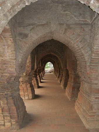
The Bhimbetka rock shelters are the collection of 750 rock shelters from which 500 are inwrought by the paintings. Situated in the Raisen District of Madhya Pradesh of India, these Stone Age rock paintings are around 30,000 years old. It is one of the largest repositories of prehistoric art in India.
The shelters were designated a UNESCO World Heritage site in 2003. In addition to the cave paintings, archaeologists have unearthed large numbers of artifacts in the caves and in the dense teak forests and cultivated fields around Bhimbetka, the oldest of which are Acheulean stone tool assemblages.
The Bhimbetka shelters exhibit the earliest traces of human life in India. A number of analyses suggest that some of these shelters were inhabited by hominids like Homo erectus more than 100,000 years ago. Some of the Stone Age rock paintings found among the Bhimbetka rock shelters are approximately 30,000 years old ( Paleolithic Age).
The name Bhimbetka is associated with Bhima, a hero-deity of the epic Mahabharata. The word Bhimbetkais said to derive from Bhimbaithka, meaning “sitting place of Bhima“. It is believed that when the five brothers, called Pandavas, were banished from their kingdom, they came here and stayed in these caves, the massive rocks seating the gigantic frame of Bhima, the second Pandava. However, these claim still remains to be corroborated with concrete evidence.
Exterior of Rock Shelters of Bhimbetka
The caves were eventually discovered in 1957-58 by accident. An archaeologist from Ujjain, Dr. Vishnu Wakankar, strayed too far from the beaten path and found himself amidst this prehistoric treasure trove. Since then more than 700 such shelters have been identified, of which 243 are in the Bhimbetka group and 178 in the Lakha Juar group. Between 1972 and 1977 excavation undertaken by Wakanakar, Misra and Hass revealed a continuous sequence of Stone Age cultures from the late Acheulian to the late Mesolithic and also some of the world’s oldest stone walls and floors.
A War Scene
The caves have evolved over time into excellent rock-shelters, ideal sites for aboriginal settlements. The smooth shape of the rocks has led some scientists to believe that the area was once under water. The rocks have taken on incredible shapes in several stunning hues and textures. Apart from the central place the aboriginal drawings have in human history, the caves themselves offer interesting material for a study of the Earth’s history.
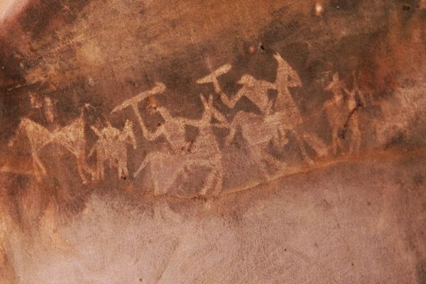
Executed mainly in red and white, with the occasional use of green and yellow with themes taken from the everyday events, the scenes usually depict hunting, childbirth, communal dancing, drinking, religious rites, burials, horse and elephant riders, animal fights, honey collection, decoration of bodies, disguises, masks and different type of animals etc. It depicts the detail of social life during the long period of time, when man used to frequent these rock shelters.The entire area is covered by thick vegetation, has abundant natural resources in its perennial water supplies, natural shelters, rich forest flora and fauna, and bears a significant resemblance to similar rock art sites such as Kakadu National Park in Australia, the cave paintings of the Bushmen inKalahari Desert, and the Upper Paleolithic Lascaux cave paintings in France.
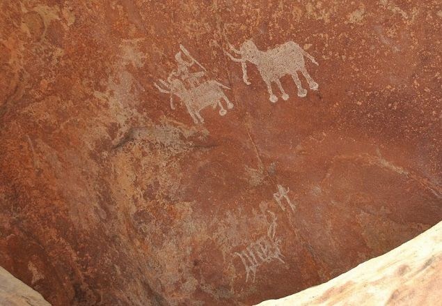
two elephants with tusks at Bhimbetka rock shelters
One rock, popularly referred to as “Zoo Rock”, depicts elephants, sambar, bison and deer. Paintings on another rock show a peacock, a snake, a deer and the sun. On another rock, two elephants with tusks are painted. Hunting scenes with hunters carrying bows, arrows, swords and shields also find their place in the community of these pre-historic paintings.
Bhimbetka rock painting showing man riding on horse. – Image Source
It is a marvel that the paintings have not faded even after thousands of years. The colors used by the cave dwellers were prepared by combining manganese, hematite, soft red stone and wooden charcoal. Perhaps, animal fat and extracts of leaves, vegetables, and roots were also used in the mixture. Brushes were made of pieces of fibrous plants. The natural pigments have endured through time because the drawings are generally made deep inside a niche or on inner walls. Some of the geometric figures date to as recently as the medieval period.
The rock art of Bhimbetka has been classified into various groups on the basis of the style and subject. The superimposition of paintings shows that different people used the same canvas at different times. The paintings, which display great vitality and narrative skill, are categorized into different prehistoric periods. The oldest are dated to the Late Paleolithic Period (Old Stone Age) and consist of large linear representations of rhinoceroses and bears. Paintings from Mesolithic (Middle Stone Age) times are smaller and portray, in addition to animals, human activities. Drawings from the Chalcolithic Period (early Bronze Age) showcase the early humans’ conceptions of agriculture. Paintings from Early Historic perioddepict religious motifs, including tree gods and magical sky chariots. Medieval paintings are geometric, linear and more schematic but show degeneration and crudeness in their artistic style.
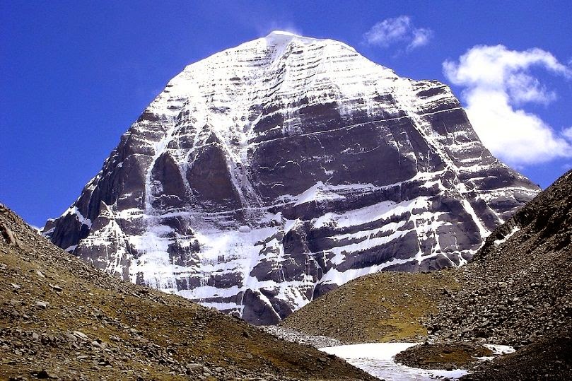
Kailash is a sacred Tibetan mountain shrouded in mystery and legends. With an impressive height of 6718 meters, Mount Kailash represents the axis of the world or the stairway to heaven for the people in the region. Both Buddhists and Hindus, as well as older religions, recognize Mount Kailash as an ancient holy place. Its shape is like the pyramids in Egypt with four nearly symmetrical sides. Its glistening snow-covered top makes it the most eye-catching one. Approach Kailash not only prohibited, but dangerous. In the immediate vicinity of mountains time flows much faster, and people have gone to the mountain, often not returned.
Its shape is remarkable and has led to speculations over the centuries. The area around this great mountain is the source of four life-giving rivers; the Indus, Brahmaputra, Sutlej and the KarnaliRiver (a tributary of the Sacred River Ganga). Two lakes are situated at the base of the mountain. The higher lake Manasarovar (one of the highest freshwater lakes in the world), is the sacred lake, and is round like the sun. The lower lake RakhastTal (one of the highest salt-water lakes) is the devil’s lake and has the shape of the crescent moon. The two lakes represent solar and lunar forces, good and negative energies respectively.
Mount Kailash is a Pyramid?
In 1999, the expedition of Russian scientists led by Professor ER Muldasheva found that the top of Mount Kailash is actually a giant man-made pyramid from ancient times. It is surrounded by more than 100 other small pyramids and various monuments, clearly oriented to the cardinal points. According to tentative estimates, the height of the rest of the complex of pyramids lie in the range 100-1800 m (for comparison: the pyramid of Cheops – 146 m). This complex, moreover, might be the centre of a worldwide system connecting other monuments or sites where paranormal phenomena have been observed. If this is true, then human history has to be re-written. It is larger than any pyramid known today.
Scientists headed by Professor ER Muldasheva concluded that the complex of pyramids Kailash, the so-called “City of the Gods“, was built by the representatives of advanced civilization, who knew the laws of subtle energy (torsion field) and the time and knew how to manage them they had been, and is subject to gravity. Otherwise it is impossible to move large masses of stone or grinding of mountain ranges that had to be done during the construction of these Pyramids, and “mirrors”.
In shape it (Mount Kailash) resembles a vast cathedral… the sides of the mountain are perpendicular and fall sheer for hundreds of feet, the strata horizontal, the layers of stone varying slightly in colour, and the dividing lines showing up clear and distinct…… which give to the entire mountain the appearance of having been built by giant hands, of huge blocks of reddish stone. (G.C. Rawling, The Great Plateau, London, 1905).
The idea of the pyramid in this region is not new. It goes back to the timeless Sanskrit epic of the Ramayana.
Vedas mentioned Mount Kailash as cosmic axis and world pillar, center of the world, and world tree. It has other names… Meru, Sumeru, Sushumna, Hemadri, Deva Parvata, Gana Parvata, Rajatadri, and Ratnasanu. Kang Tisé or Kang Rinpoche (the ‘Precious Jewel of Snow’ in Tibetan), Meru (or Sumeru), Swastika Mountain, Mt. Astapada, Mt. Kangrinboge (the Chinese name) – all these names, real or legendary, belong to one of the holiest and most mysterious mountains in the world – Mount Kailash. In religion or mythology, the world center or the connection is between Heaven and Earth. As the celestial pole and geographic pole, it expresses a point of connection between sky and earth where the four compass directions meet.
According to Hinduism, Lord Shiva, the destroyer of ignorance and illusion, resides at the summit of mountain Kailash, where he sits in a state of perpetual meditation along with his wife Pārvatī. Hindu mythology recognises it as the only abode of the gods that can be visited by man in his mortal body.
To Tibetan Buddhists, Kailash is the abode of the tantric meditational deity Demchog. Jains revere Kailash as the site at which their first prophet received enlightenment. The Bön, an aboriginal religious sect of the Tibetan pre-Buddhist era call it Yung-drung Gu-tzeg, or “9-storey Swastika” because on the south face of Kailash can be seen a swastika.
Perhaps the Buddhist legends about Mount Kailash gives the most interesting indication of its true significance. Buddhists believe that ‘their’ sorcerer Milarepa challenged the sorcerer of the Bön religion, Naro Bön-chung. There was a fierce superhuman battle, but both sorcerers turned out to be equally powerful. They then decided to race each other to the top of Mount Kailash. Now what is interesting is that one of them used some sort of magic drum to reach the top, while the other won by using ‘rays of the sun’.
What does this sound like, if we take it literally? Did one of these legendary figures use a spacecraft and the other some form of teleportation? What if these magicians were actually ancient aliens, using advanced technology that primitive humans could only explain by calling them ‘Gods’?
However, it is only fair to add that the Russian claims to have discovered in the Mt.Kailash area the highest ever human-built pyramids were denied three years later by Chinese scientists in the official Chinese Press.
Reference: http://www.unspecial.org/UNS640/t47.html
Nalanda University was an ancient centre of learning in India. Established in the 5th century AD by Gupta Kings, Nalanda University was among the first great universities in recorded history, pre-dating such institutions of higher learning like Al-Azhar in Egypt (10th century AD), the University of Bologna in Italy (11th century AD), and Oxford University in England (12th century AD).
By continuing to use the site, you agree to the use of cookies. more information
The cookie settings on this website are set to "allow cookies" to give you the best browsing experience possible. If you continue to use this website without changing your cookie settings or you click "Accept" below then you are consenting to this.


 Since then, Louis has continued to study the cells with an international team including Chandra Wickramasinghe from the University of Cardiff in the UK and one of the leading proponents of the panspermia theory, which he developed in the latter half of the 20th century with the remarkable physicist Fred Hoyle.


