Archaeologists in Oman’s southern Sinaw region have discovered a site that could reveal Indus Valley civilisation’s influence on the Omani society 2,300 years ago, officials said. The tomb of a buried man with sword and daggers made of iron and steel was unearthed during an excavation and it has been scientifically proved that iron and steel arms were made in the Indus Valley civilisation first time ever.
Sultan Bensaif Al Bakri, director of Excavations and Archeological Studies of the Ministry of Heritage and Culture has said that this finding may prove the influence of the Indian civilisation on Oman during that period. However, he said that further studies would be carried out on this regard.
The tomb was found during an excavation located around 22km south of Sinaw in Oman. The underground chamber, which dates back to 300 BC, contained the remains of a middle-aged man with a robe, woollen cap, and leather boots, along with his personal arms – a sword and two daggers. The sword has an intricate handle partly covered with textured ivory shaped like an eagle’s beak. The daggers were tied on the right and left sides of his waist. Near his grave, two male and female camels were also buried. They were slaughtered after the death of the man. The walls of the graves of these camels were erected with stones. The man’s garments and sword suggest he was a chieftain of a tribe.
According to the descriptions provided by the archaeologists, the sword and daggers were made of iron and steel which was first made in the Indian civilisation from where it spread to the neighbouring civilisations, including Oman, said Al Bakri.
Indus Valley Civilization is one of the three oldest urban civilizations, along with Egypt and Mesopotamia.
The Ministry of Heritage and Culture will restore these arms and will display these models in the proposed national museum scheduled to open at the end of this year.
This finding was made during a rescue excavation carried out by the Ministry of Heritage and Culture in coordination with the ministry of transport and communications that was working on the project of Sinaw-Mahout-Duqm road.
While digging, the Ministry of Transport and Communications found a graveyard spread across 100 sq m. This major archaeological finding was made when the ministry excavated 35 graves that came in the way of the proposed road. Source: Times of Oman
Jatinga is a village on a ridge, is located in Dima Hasao District, Assam State in India. It is 330 km south of Guwahati. The village is inhabited by about 2,500 Khasi-pnar tribal people and few Dimasa people. This small Village is famous for the phenomenon of birds “committing suicide”. Over the last 100 years, thousands of birds have flown to their death over a small strip of land in Jatinga, India.
The Bird Suicide Mystery is a unique phenomenon that occurs at Jatinga between September and November each year. During these late monsoon months, several migratory and local birds commit mass suicide at the village. Just after sunset, between 7 and 10 pm, hundreds of birds descend from the sky, plummeting to their deaths by crashing into buildings and trees. Since birds aren’t known to be suicidal, the phenomenon has baffled villagers, visitors and scientists alike.
Many ornithologists have dedicated their time in research of this unnatural phenomenon. They have found that there are many species of local birds such as Kingfishers, Pond Heron, Black Bittern, Tiger Bittern, etc. are subjected to such strange behaviour. Studies have also revealed that the birds commit suicide in Jatinga during the late monsoon as most of the water bodies in Assam are flooded by that time. The birds lose their natural habitat. So they appear to be migrating to other places, and Jatinga is in their migratory path. But it isn’t clear why the birds fly at night, or why they get voluntarily trapped at the same place every year.
In 1988 when Assam faced severe floods maximum number of bird suicides was reported in Jatinga. Some of the long distance migratory birds are not affected by this phenomenon.
Curiously, most of the doomed birds do not attempt to fly away after they land near the lights. They look dazed and disheveled, perhaps due to the trauma of the whole shocking experience. Such birds fall easy prey to the villagers. Some of the birds hovering around the light sources are brought down by a vigorous swing of the bamboo poles. Catapults are also used to bring down the birds in flight as well as those perching on the trees and bushes near the light sources. However, contrary to the popular belief, birds do not commit suicide. Under circumstances not yet fully explained, these birds get caught in the fog and wind, get disoriented and seek solace of the light sources put out by the villagers. They hit against trees or other objects and get injured in their flight towards the light source. The villagers hit the hovering birds with bamboo poles or catapults to bring them down.
Studies also show that the birds come in only from the North and land only on a well-defined strip in the village – that’s 1.5 km long and 200 meters wide. Lights placed along the southern side of the village have failed to attract any birds.
“It is not suicide, to be precise,” said Anwaruddin Choudhury, a well-known ornithologist in Assam. “But the fact remains that birds are attracted by light and fly towards any object with a light source. This phenomenon still puzzles bird specialists.”
The phenomenon of ‘avian harakiri’, as the locals call it, was first observed by the Zeme Nagas, the inhabitant tribe of the region in the early 1900s. It frightened them so badly that they sold their land to Jaintias and left the place in 1905. The new inhabitants also observed the phenomenon, but interpreted it as a gift from God.
The Jaintias aren’t entirely wrong. After all, the phenomenon has captured the interest of wildlife circles and tourists, making the village of Jatinga world famous. The birds alone are responsible for a boost in tourism during the monsoon months. And they’re quite delicious; locals relish these exotic delicacies. The villagers deliberately switch on lights and lanterns to attract the birds and capture them every year.
In the Prince’s Library of Ujjain in India, there is a well preserved document called the ‘AgastyaSamshita‘, which dates back to the first millennium BC. It contains a detailed description not only of how to construct an electric battery/cell, but also, how to utilize the battery to ‘split’ water into its constituent gasses.
Modern battery cell resembles Agastya’s method of generating electricity. For generating electricity, Sage Agastya had used the following material: One earthen pot, Copper plate, Copper sulphate, Wet saw dust, Zinc amalgam
“Place a well-cleaned copper plate in an earthenware vessel. Cover it first by copper sulfate and then moist sawdust. After that put a mercury-amalgamated-zinc sheet on top of an energy known by the twin name of Mitra-Varuna. Water will be split by this current into Pranavayu and Udanavayu. A chain of one hundred jars is said to give a very active and effective force.”
When a cell was prepared according to Agastya Samhita and measured, it gives open circuit voltage as 1.138 volts, and short circuit current as 23 mA.
Translation: He says that if we use the power of 100 earthen pots on water, then water will change its form into life-giving oxygen and floating hydrogen.
Translation: In an iron vessel and in a strong acidic medium, gold or silver nitrate covers copper with a layer of gold or silver. The copper that is covered by gold is called shatakumbha or artificial gold.
These things came to light when Rao Saheb KrishnajiVajhe had passed the engineering exam in 1891 from Pune. While looking for scriptures related to science, he found a few pages of the Agastya Samhita with Damodar Tryambak Joshi of Ujjain. These belonged to around Shaka Samvat 1550. Later on, after reading the said description in the pages of the Samhita, Dr.M.C.Sahastrabuddhe, the Head of the Sanskrit Department in Nagpur felt that the description was very similar to that of Daniel Cell. So he gave it to P.P. Hole, the Professor of Engineering at Nagpur, with a request to investigate.
When Mr. Hole and his friend started preparing the apparatus on the basis of the above description, they could understand all the things except shikhigreeva. On checking the Sanskrit dictionary, they understood that it meant the neck of a peacock. So, he and his friend went to Maharaj Bagh and asked the chief when a peacock would die in his zoo. This angered the gentleman. Then they told him that they needed its neck for an experiment. The gentleman asked them to give in an application. Later, when during a conversation, they narrated this to an Ayurveda expert, he burst out laughing and said that here it did not mean the neck of a peacock, but a substance of that colour, that is copper sulphate. This solved the problem. Thus, a cell was formed and measured with a digital multimeter. It had an open circuit voltage of 1.38 volts and short circuit current of 23 milli amperes.
The information that the experiment was successful was conveyed to Dr.M.C. Sahastryabuddhe. This cell was exhibited on August 7, 1990 before the scholars of the fourth general meeting at the Swadeshi Vigyan Sanshodhan Sanstha, Nagpur. It was then realised that the description was of the electric cell. They investigated as to what the context was and it was realised that Sage Agastya had said many things before this.
Rao Saheb Vajhe, who spent his life in rummaging the Indian scientific scriptures, and discovering various experiments, gave different names to electricity on the basis of the Agastya Samhita and other scriptures and that electricity is created in different ways. Ancient Vedic technologists produced six kinds of electricity:
Tadit—the one produced by friction from leather or silk,
Saudamini—that produced by friction from gems or glass,
Vidyut—produced from clouds or steam,
Shatakoti alias Shatakumbhi—that produced from a battery of hundreds of cells,
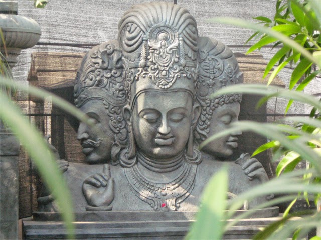
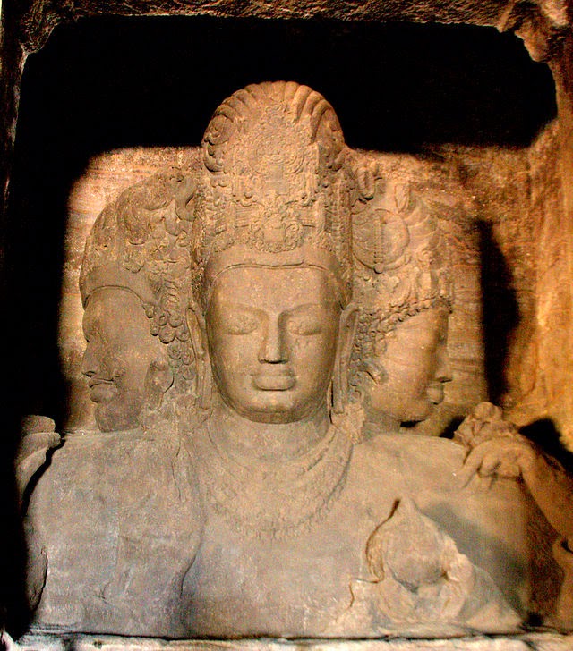
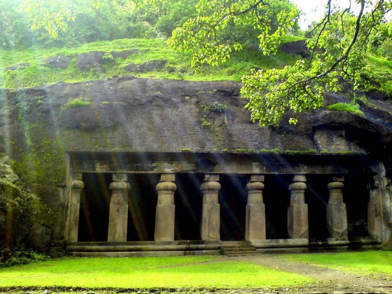
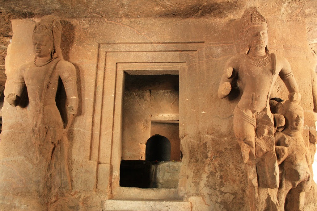
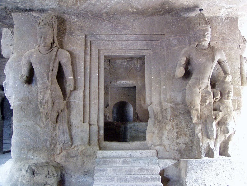
The Elephanta Caves are a complex of ancient cave temples on Elephanta Island, located 10 km away from the Gateway of India at Mumbai. One of the oldest rock cut structures in the country, the Elephanta Caves are the perfect expressions of archaic Indian art associated to the cult of Lord Shiva.
Here, Indian art has found one of its most perfect expressions, particularly the huge high reliefs in the main cave. Here you will find two categories of caves; one is the Hindu rock art and the other is the Buddhist rock art. The place is still worshipped by the locals, and is dedicated to Lord Shiva. One can spot some resemblance to the Ajanta and Ellora caves, which are around 300 km from Elephanta.
The origins of the Elephanta Caves have been debated time and again, though the sculptures and the art speak volumes about the time from when they could have been popular-6th or the 8th century.
The island on which the caves are built was originally known as Gharapuri, and the Portuguese retitled it as Elephanta Island when they discovered a large stone structure of an Elephant on the island. However, it is believed that the Portuguese destroyed many other structures and even used the idols of Hindu Gods within the caves for target practice.
Shortly before the Elephanta temples were created, Bombay had experienced the golden age of the late Guptas, under whom the arts flourished. Sanskrit had been finely polished, and Kalidasa and other writers had helped incite a Hindu religious revival under the court’s liberal patronage. Shaivism, the worship of Shiva, inspired the building of these temples.
Many of Elephanta’s priceless statues were damaged or destroyed by the Portuguese, who apparently used the Hindu gods for target practice. There have also been reports of vandalism and carelessness by modern visitors.
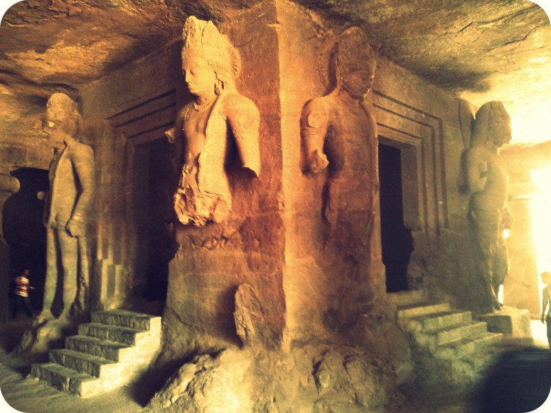
This rock cut temples were created by carving out rock, and creating the columns, the internal spaces and the images. The entire temple is akin to a huge sculpture, through whose corridors and chambers one can walk. The entire complex was created through a process of rock removal. Some of the rock surfaces are highly finished while some are untreated bare rock. The entire cave temple complex covers an area of about 60000 squrare feet.
There are two groups of caves. To the east, Stupa Hill (thus named because of a small brick Buddhist monument at the top) contains two caves, one of which is unfinished, and several cisterns. To the west, the larger group consists of five rock-cut Hindu shrines. The main cave is universally famous for its carvings to the glory of Shiva, who is exalted in various forms and act ions. The cave consists of a square plan mandapa whose sides measure about 27 m.
Shiva as Nataraja (Cosmic dancer)
Various temples are cut out of rock, along with columns. The space inside consists of a main chamber and has two lateral chambers, shrines and courtyards. Above the temples you can see the natural rock out of which the temples have been carved. The entrance provided is from three sides. What attracts the visitor most are the Trimurti, Shivalingam, Kalyansundara, Gangadhara, Uma maheswara and Ardhanarisara sculptures, which are all the forms of Lord Shiva.
To the east of the main temple is a courtyard, flanked by the secondary shrine. This temple contains six pillars at its entrance, four of which are free standing and two engaged. The entrance leads to a hall decorated with sculptured panels depicting legends from the Shiva Purana.
One statue shows Shiva bringing the Ganges River down to Earth, letting it trickle through his matted hair. He is also depicted as Yogisvara, lord of Yogis, seated on a lotus, and as Shiva Nataraja, the many-armed cosmic dancer.
Elephant Lingam shrine – photo by SivarajSmaller Cave, Elephanta – Photo by Elroy Serrao
In 1942 a British patrol in Roopkund, India made a shocking discovery. Approximately 17,000 feet above sea level, at the bottom of a small valley, was a frozen lake full of human skeletons. That summer, the ice melted to reveal even more skeletal remains, floating in the water and lying haphazardly around the lake’s edges. Had something horrible had happened here?
Scientists now believe they have finally solved the mystery of how and why the skeletons of over 200 people were found in a frozen lake in northern India.
Lake Roopkund is located in northern India along the border of Nepal at 4,800 meters (~16,000 ft) above sea level with edges covered in snow for most of the year. The water is rather shallow, only reaching a maximum depth of 2 meters, and frozen most of the year. The frozen climate at this altitude has aided significantly in the preservation of hair, soft tissue, and leather clothing, prompting the everyone to believe these were recent deaths. These skeletons were initially thought to be the bodies of Japanese soldiers who had died of exposure while travelling through India as part of a World War II invasion. More recent analyses conclude the remains were much older than anyone expected, dating them to approximately 850AD.
The significant amounts of soft tissue present first confused everyone. How could these skeletons be old if there was still flesh on the bones?
Who were these people? DNA evidence of the remains indicates there were two distinct groups – (1) a closely related or family group, and (2) a shorter group of local people, likely hired as porters and guides. Many artifacts (spears, leather shoes, rings, etc.) were found among remains, leading experts to conclude the family group was most likely made up of pilgrims heading through the valley with the help of the locals as guides.
What happened to them? It was initially proposed these people died as a result of exposure, perhaps trapped in an avalanche. But closer inspection of the bones reveals evidence of perimortem trauma on many of the skeletons. This is trauma that occurred at the time of death. Scientists apparently discovered a surprising pattern, in which the skulls and mostly bones of the upper body were inflicted with a similar type of trauma.
Remains showcased on a boulder along with artifacts–personal belongings such as leather shoes
Were they murdered? According to experts, the skeletons only showed signs of one type of perimortem wound. Furthermore, they did not have typical wounds indicative of the time period’s weaponry. Instead, experts determined the injuries were indicative of an impact from a large, rounded object.
A 2004 expedition to the lake revealed a new and unexpected scenario that could have led to the death of over 200 people. The prevalence of head and shoulder injuries led experts to wonder if their deaths were the result of something falling from above. Taking skeletal evidence and the cold environment into consideration, it is now proposed injuries were due to a sudden and severe hailstorm in which people were pelted with large hailstones (estimated 23 cm/9” diameter). Trapped in a valley with no shelter, there would have been no easy escape, thus resulting in this mysterious mass of skeletons. Their bodies remained hidden in the glacial valley, freezing and thawing for the next 1,200 years until their gruesome discovery.
Is this event really possible? It’s difficult to assess this traumatic scenario without seeing images of the vaguely described skeletal trauma. But a quick web search of hailstones reveals they can indeed reach sizes of 9 inches that experts proposed. The largest hailstone collected in the US measured 8 inches across and weighed in at almost 2 pounds. Despite some extreme sizes of hailstones, only 3 individuals have died in the US (in 3 separate storms).
Historical records indicate that the deadliest hailstorm occurred on April 30, 1888 in the northern districts of India, killing 230 people. The hailstones were reportedly as big as oranges, accumulating up to 2 feet high. Although rare, it appears these freak hailstorms with monstrous hailstones have a history of forming in the Deccan Plateau of India and in Bangladesh. Recently around January 31, 2013, a severe 20-minute hailstorm suddenly struck several villages in the state of Andhra Pradesh in southern India, killing 9 people. The short duration of storms may account for a minimal amount of trauma to the lower body.
The deaths at Rookpund Lake could very likely be the result of a freak hailstorm. Although they are quite rare, history indicates these hailstorms do have a higher occurrence in that particular area and have been known to produce small boulder-sized hailstones. Taking all of the evidence into consideration, it seems probable that a very short but intense hailstorm would have led to the death of ~200 individuals in 850AD, thus solving this curious mystery.
An archeologist of India found 10000 years old paintings depicting Aliens and UFO in a Cave near Chhattisgarh, India. According to archaeologist JR Bhagat, these paintings have depicted aliens like those shown in Hollywood and Bollywood flicks and says they may serve as evidence that Earth was once visited by an advanced alien civilization.
In 1906, Gandhi cheered on the British as they waged a war on the black Zulus. He then volunteered for military service himself, attaining the rank of Sgt. Major in the British Army and assisting the war on blacks in every way he could.
Gandhi is idolized worldwide as a prophet, a visionary, even a messiah. Earl Mountatten, the last Viceroy of India, said, “Mahatma Gandhi will go down in history on a par with Buddha and Jesus Christ.” The accuracy of his statement can be seen in modern Hindu temples, such as the “Gandhi Temple” of Bhatra village, Sambalpur District, where Gandhi is worshiped as a deity.
Gandhi is to India what George Washington, Thomas Jefferson, and James Madison were to the United States. He was a primary leader in Indian political movements in both South African and India and his political philosophy prevails in India. All politicians there acknowledge him as their political, philosophical, and spiritual for bearer, even worshiping at his tomb, Raj Ghat. He is even worshiped as a god by many Hindus. Even the United Nations honored him, choosing his birthday as an “International Day of Non-Violence.”
Gandhi was a first-class racist.
Many years ago, the lack of efficient methods of communication and documentation allowed Gandhi to effortlessly create a convincing but false image of himself. People had no way to adequately investigate his past or properly track his present activities, so the truth remained hidden for decades.
The popular image of Gandhi is a myth. Gandhi was deeply prejudiced against all minorities, from black Africans to low-caste Hindus. He also demonstrated a shocking lack of morality, from sleeping naked with young girls to employing nonviolence merely as a tool of political expedience.
Gandhi’s writing, compiled in an uncensored series of volumes by the Government of India, is liberally sprinkled with verbal violence against the black South African natives, who he termed “Kaffirs.” His animosity towards black people is almost tangible and his racism is undeniable. A brief but shocking example illustrates Gandhi’s racism.
Gandhi was hired to work as an attorney for wealthy Indian traders in South Africa. He moved there in 1893 and soon helped establish the Natal Indian Congress. The Natal Indian Congress was founded in 1894 by Mohandas Gandhi to further the causes of caste Hindus and campaign against equal treatment for Indians and black South African natives. The major achievement of the Congress was the successful attempt, spear-headed by Gandhi, to fix the Durban post office “problem.”
The Durban Post office
The first major accomplishment of the Natal Indian Congress was to further entrench racial segregation into South African society during a time of massive racial strife. In the city of Durban, there was a post office with two doors – one for blacks and Indians and another for whites. Gandhi, of course, was required to use the door for blacks and Indians. This deeply offended him, not because of the segregation, but because he was “forced” to share a door with blacks, which he felt was beneath him. Gandhi successfully lobbied to correct this “problem” by building a third entrance for Indians, thus further entrenching the South African policy of segregation.
This achievement is shocking but very well-documented in Gandhi’s writings. In his Collected Works (CWMG), Vol. I, pp. 367-368, Gandhi wrote: “For the present our efforts are concentrated towards preventing and getting repealed fresh legislation. Before referring to that, I may further illustrate the proposition that the Indian is put on the same level with the native in many other ways also. Lavatories are marked ‘natives and Asiatics’ at the railway stations. In the Durban Post and telegraph offices there were separate entrances for natives and Asiatics and Europeans. We felt the indignity too much and many respectable Indians were insulted and called all sorts of names by the clerks at the counter. We petitioned the authorities to do away with the invidious distinction and they have now provided three separate entrances for natives, Asiatics, and Europeans.”
Gandhi Refuses to Share Door With Blacks
Gandhi first referenced this issue in an August, 1895 letter titled “Report of the Natal Indian Congress.” He wrote: “A correspondence was carried on by the late President with the Government in connection with the separate entrances for the Europeans and Natives and Asiatics at the Post Office.”
Gandhi Achieves Post Office Segregation
In his 1895 “Report,” Gandhi boasted about the government response to his petition for segregation from the blacks. He wrote: “The result has not been altogether unsatisfactory. Separate entrances will now be provided for the three communities.” Again, in his 1896 “Grievances,” he bragged about this victory, writing: “We petitioned the authorities to do away with the invidious distinction and they have now provided three separate entrances for natives, Asiatics and Europeans.”
A year later, after the issue had already been resolved, Gandhi chose to expound upon his reasons for raising it in the first place. In his August 14, 1896 letter, “The Grievances of the British Indians in South Africa: An Appeal to the Indian Public,” he called being “put on the same level with the native” a “disability.” He did not complain that Indians were refused the same rights as whites, but rather that Indians were not treated as legally superior to the black natives.
Gandhi’s “Grievances” letter continues: “Lavatories are marked ‘natives and Asiatics’ at the railway stations. In the Durban Post and Telegraph Offices, there were separate entrances for natives and Asiatics and Europeans. We felt the indignity too much and many respectable Indians were insulted and called all sorts of names by the clerks at the counter.”
Obviously, Gandhi was infuriated by the idea of integration with the black natives. He didn’t mind that Indians were segregated from whites as long as the Indian was not “dragged down to the position of a raw Kaffir.”
Gandhi Seeks Further Segregation
He was not satisfied, however, and in 1896 raised the “problem” of other integrated locations. The integrated railway station lavatories displeased him, for instance, and in “Grievances” he wrote that “our efforts are concentrated towards preventing and getting repealed fresh legislation.” His efforts to increase racial segregation continued for many years. In an 1894 Indian Opinion article, for instance, he again protested integration with the blacks, writing: “Why, of all places in Johannesburg, the Indian location should be chosen for dumping down all Kaffirs of the town, passes my comprehension. Of course, under my suggestion, the Town Council must withdraw the Kaffirs from the Location. About this mixing of the Kaffirs with the Indians I must confess I feel most strongly. I think it is very unfair to the Indian population, and it is an undue tax on even the proverbial patience of my countrymen.”
Indeed, Gandhi felt Indian segregation was something worth boasting about. In a March, 1903 Indian Opinion article, he wrote: “The petition dwells upon `the co-mingling of the colored and white races.’ May we inform the members of the Conference that so far as British Indians are concerned, such a thing is particularly unknown. If there is one thing which the Indian cherishes more than any other, it is the purity of type.”
In 1904, Gandhi founded The Indian Opinion, a newspaper which he used as a political tool to promote his personal views. It is in this paper, which Gandhi edited until 1914, that we find a record of his extensive anti-black activism and opinions. A list of anti-black quotes from his writings, in which he invariably refers to the South African natives as “Kaffirs. Gandhi’s opinion of the native is best summarized when he calls them people “whose occupation is hunting, and whose sole ambition is to collect a certain number of cattle to buy a wife with and, then, pass his life in indolence and nakedness.”
Kumari Kandam is the legendary sunken continent, according to many of the ancient extant Tamil literatures and some of the Sanskrit literatures. Almost 100 years back tamil nationalists came to identify and associate Kumari Kandam with Lemuria, a hypothetical “lost continent” posited in the 19th century to account for discontinuities in biogeography.
Located in the Indian and Pacific Oceans but now sunken, this sunked continent is believed to be the connections between Africa to South India, through Madagascar.
Many of the earliest extant Tamil literary works and their commentaries, mentions a Tamil continent called Kumari Kandam, which was ruled by Pandiyan Kings for 10,000 years, before getting submerged in the Indian Ocean, south of present-day Kanyakumari district at the southern tip of India.
References of Kumari Kandam from some of the Tamil literary sources
According to Silappadhikaram,one of the Five Great Epics of Tamil Literature written in 2nd century CE, states that the cruel sea took the Pandiyan’s land, part of which was present between the rivers Pahruli and the mountainous banks of the Kumari. These rivers are said to have flowed in a now-submerged land.
Adiyarkkunallar, a 12th-century CE commentator on the epic, explains this reference by saying that there was once a land to the south of the present-day Kanyakumari, which stretched for 700 kāvatam from the Pahruli river in the north to the Kumari river in the south. The modern equivalent of the measurement kāvatam, which is also known as kātam in Tamil, is a distance of 6.25 miles (10.06 km).
Kanakkathikaram, a 15th century Tamil Mathematical literary work which is in the form of poems, defines the length of 1 kāvatam(1 kātam) as 24,000 muzham (33,000 feet, 6¼ miles) and it also defines the time taken to cover it which is the distance that can be covered by normal walk in 7½ Nāzhigai or 1 Sāmam (equivalent to 3 hours). So, the distance of 700 kāvatam is equivalent to 4,375 miles (7,041 km) in modern day measurements.
This land was divided into 49 territories, which he names as Seven coconut territories (elutenga natu), Seven Madurai territories (elumaturai natu), Seven old sandy territories (elumunpalai natu), Seven new sandy territories (elupinpalai natu), Seven mountain territories (elukunra natu), Seven eastern coastal territories (elukunakarai natu) and Seven dwarf-palm territories (elukurumpanai natu). All these lands, he says, together with the many-mountained land that began with KumariKollam, with forests and habitations, were submerged by the sea. Two of these territories were supposedly parts of present-day Kollam and Kanyakumari districts.
The 7th century CE commentary written by Nakkīranār for the Tamil literary work Iraiyanar Akapporul, gives the list of Pandiyan kings who ruled the Kumari Kandam. It also gives information about the three Tamil Sangams (assemblies of Tamil scholars and poets who do research on Tamil language and also creates literary works) which spans about 10,000 years.
According to th Kumari Kandam tradition, over a period of about just 11,000 years, the Pandyans, a historical dynasty of Tamil kings, formed three Tamil Sangams, in order to foster among their subjects the love of knowledge, literature and poetry. These Sangams were the fountain head of Tamil culture and their principal concern was the perfection of the Tamil language and literature. The first two Sangams were not located in what is now South India but in antediluvian Tamil land to the south which in ancient times bore the name of Kumari Kandam, literally the Land of the Virgin or Virgin Continent.
The First Sangam (Mutaṟcaṅkam) is described as having been held at the Pandiyan King’s capital city, Madurai (Kadal Konda Then Madurai – which means Southern Madurai which was submerged in the sea. The old Madurai was called as Southern Madurai to differentiate it with the capital city of Madurai of third Sangam), which lasted a total of 4440 years, and had 549 members, which supposedly included some gods of the Hindu pantheon such as Siva, Kubera and Murugan. A total of 4449 poets are described as having composed songs for this Sangam. There were 89 Pandiyan kings starting from Kaysina valudi to Kadungon were decedents and rulers of that period.
If credence is given to this commentary, then the beginning of first Sangam should be placed somewhere in 9000 B.C.
Most of the lands of Kumari Kandam were submerged in the sea during first devouring of the land by the sea. Then, the Pandiyan King and the remaining people migrated to the remaining land of Kumari Kandam and the king moved his capital to Kapatapuram. At the same time, the present location of Tamil Nadu was ruled by Chera, Chola, and 46 other small kingdoms.
The Second Sangam (Irandaam Caṅkam, Iṭaicaṅkam) was convened in Kapatapuram, the then capital city of Pandiyan King. This Sangam lasted for 3700 years and had 59 members, with 3700 poets participating. There were 59 Pandiyan kings starting from Vendercceliyan to Mudattirumaran were decedents and rulers of that period.
This city was also submerged in sea. Ramayana and Arthasastra of Kautalya corroborates the existence of a city named kavatapuram. There is a reference to a south Indian place called kavata by sugriva in a verse which runs something like ‘having reached Kavata suitable for Pandiya‘. The place kavata is also mentioned by Kautalya (also known as Acharya Chanakya) in Arthasastra.
Having lost the complete Kumari Kandam, the Pandiyan King conquered the part of lands belonging to the Chola and Chera kings (Silapathikaram, Maturaikkandam, verses 17-22) and made Korkai, a seaport on the southernmost tip of the Indian Peninsula, as his capital and in later times moved his capital to the current city of Madurai.
The Third Sangam (Moondraam Caṅkam, Kaṭaicaṅkam) was purportedly located in the current city of Madurai, the then capital city of Pandiyan King, and lasted for 1850 years. There were 49 Pandiyan kings starting from Mudattirumaran (who came away from Kabadapuram to present Madurai) to Ukkirapperu valudi were decedents and rulers of that period.
The academy had 49 members, and 449 poets are described as having participated in the Sangam.
Map of Lemuria or Kumari kandam in Indian ocean
References of Kumari Kandam in Puranas and Ancient Tamil Literature
Bhagavata-Purana, 10th Skanda.
In Tamil literary works Aintiram, Silappadhikaram, Manimekhalai and SaivamPaayanam and in Sanskrit literary work Bhagavatha Purana, there are information about Tamil sage Mayan, who wrote one of the Tamil Sangam literary works Aintiram, and was part of Tamil Sangams and lived in Kumari Kandam.This sage also wrote other Tamil literature Pranava Vedham (which is called by Vyasa as the predecessor of four Vedas in Bhagavatha Purana), MayaMatham (Book about Architecture, Sculptures and Vasthu) and SuriyaNool (Book about Astronomy and Astrology), one Tamil grammatical work, etc. According to Aintiram, Kumari Kandam was a land which has huge area and the PalThuli river (PalThuli – Divided grammatical form of Pahruli according to Tamil grammar which means many drops), one of the Kumari Kandam rivers, originated from PeruMalai(means big mountain – represents MeruMalai – Meru Mountain). It also tells that there were 49 lands in Kumari Kandam.Tamil literary work SaivamPaayanam gives information about Kumari Kandam and its territories. It also mentions the existence of PeruMalai (MeruMalai – Meru Mountain) in Kumari Kandam.
The Tamil literary work Manimekhalai, mentions about multiple Tsunamis in the ancient city of Poompuhar and was swallowed up by the sea. This event is supported by archeological finds of submerged ruins off the coast of modern Poompuhar.
The Tamil poetic literature Tamil vidu thoothu describes the Topography of Kumari Kandam. It is also said that the Pahruli river was excavated to irrigate the mountain valley by the Pandiyan King Nediyon.
The third Sangam literary work Purananooru talks about Kumari Kandam and the river Pahruli which was there in Kumari Kandam.
The Tamil Grammar work Nannool talks about the sunken country Kumari Kandam.
The Tamil literature SiruKakkaip Paadiniyaar talks about the Kumari Kandam.
There are references for Kumari Kandam present in Kantapuranam, which mentions it as one of the nine continents of old times, or one of the nine divisions of India and the only region not to be inhabited by barbarians.
According to the Matsya Purana, Manu was the king of Dravidadesa (South Indian country) in Kumari Kandam.
There are references for Kumari Kandam present in Garuda Puranam. Also, There are scattered references in Sangam literature, such as Kalittokai 104, to how the sea took the land of the Pandiyan Kings, after which they conquered new lands to replace those they had lost.
References of Kumari Kandam (Lemuria) in Chinese & Greek Literature
In some of the ancient Chinese chronicles, there are references to Pahruli river, Peru river and Meru Mountain (with 49 peaks) from where the Kumari River, Peru river and Pahruli river were originated (according to Tamil literature). It is said that Chinese laborers were employed by the Pandiyan King and when they went down the mines they appeared like a huge army of small ants. Therefore, they were called pon thondi erumbukal (Gold mining ants). This is also confirmed by ancient Chinese chronicles.
Megasthenes (ca. 350 – 290 BCE), a Greek ethnographer and explorer in the Hellenistic period, authored the work Indika, the account of his travels in India. In this work, he says that Taprobane (old name of Sri Lanka) was separated from the mainland (Indian Peninsula) by a river, which means that during the period of Megasthenes, Sri Lanka could have been connected to Indian Peninsula by a small landmass in between them and was divided by Thamirabarani River (Porunai River).
The current Thamirabarani River in Tamil Nadu flows into the sea suggests that the Thamirabarani River would have reached Sri Lanka through a now-submerged landmass existed between Indian Peninsula and Sri Lanka during the period of Megasthenes.
Archaeological Data supporting existence of Kumari Kandam
archeological findings at Poompuhar
The marine archeological findings at Poompuhar (Tamil Nadu) by marine archeological research conducted by the National Institute of Marine Archeology (Goa) reveals that much of the town of Poompugar (Tamil Nadu) was washed away by progressive erosion and a Tsunami around 300 BC.
Ancient Pottery dating back to the 4th century BC have been discovered off shore by marine archeologists east of this town. The timeline of this Tsunami also coincides with the timeline (after the period of Megasthenes visit to India) of the submergence of landmass which was claimed to be existed between Indian Peninsula and Sri Lanka according to Megasthenes accounts.
The geological survey reveals that most of the places in the land under the sea, where Kumari Kandam is claimed to be existed, has the maximum depth of the sea of 200 meters. In some of the places, the maximum depth of the sea is 2000 meters. Since, these areas has low sea depth, there are more possibilities to exists a now-submerged land in which people lived.
Languages spoken by Australian tribes, African tribes, Andaman and Nicobar tribes and Lakshadweep tribes are identical to Tamil language. So, there are high possibilities that there might be a connecting land which exists in between India, Australia and Madagascar
Types of plants, trees and animals present in Africa and Madagascar are identical with that of in India. So, there might be a connecting land which exists in between India and Madagascar.
Expedition to Poompuhar – Remains of Kumari Kandam
By continuing to use the site, you agree to the use of cookies. more information
The cookie settings on this website are set to "allow cookies" to give you the best browsing experience possible. If you continue to use this website without changing your cookie settings or you click "Accept" below then you are consenting to this.